|
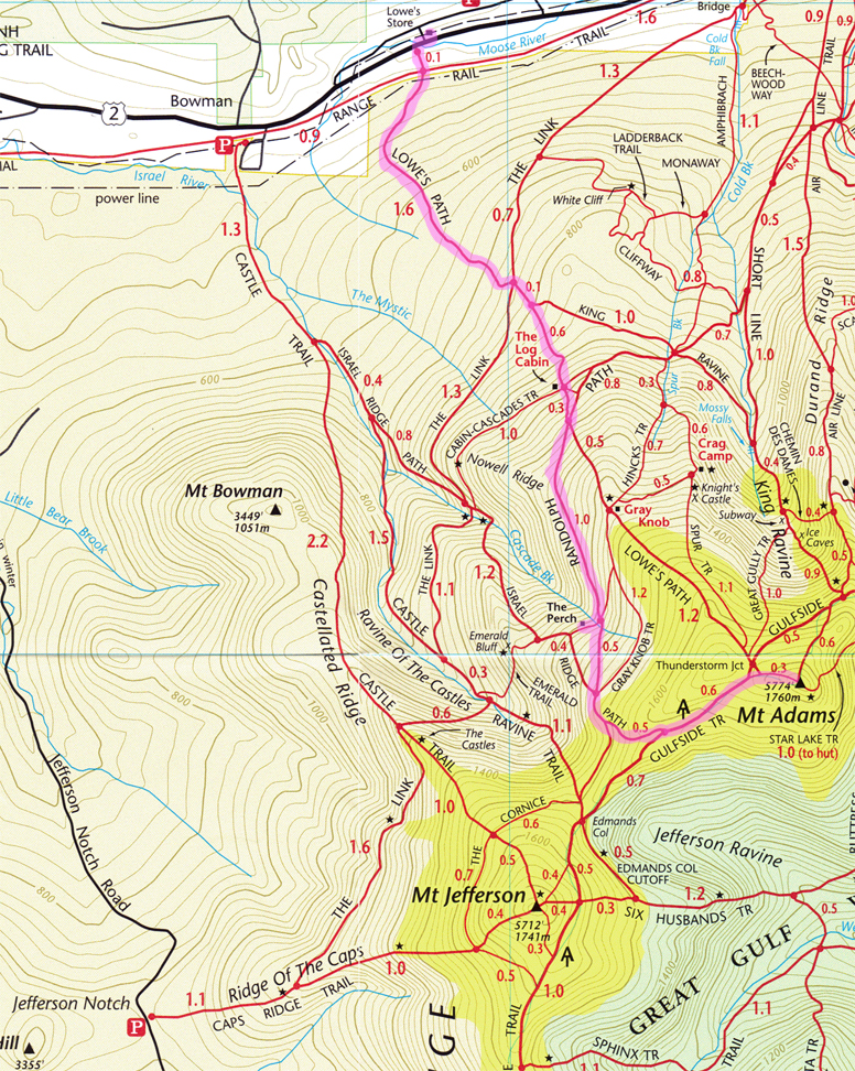
We started our journey from The Perch, a lean-to with four tent platforms, situated between the
Randolph and Israel Ridge Paths. After filling up at the Cascade Brook, we ascended the Randolph
Path till it joined with Israel Ridge Path, where we hit the tree-line. I think it was there that
we saw the sign that read “Many people have died here from exposeure even in the summer”. It made
me think of the winter gloves that my hiking buddies had brought. I thought it was a little overkill.
From there it was a 1.5 - 2.0 hour hike to the summit. There are great views along this trail down
to the Ravine Of The Castles. Above tree-line the Israel Ridge Path has become all rock where you
carefully go from cairn to cairn. Staring at just rock will put a strain on your eyes and I swear
that I saw a deer or some type of land mammal in the distance. The only problem was that it was not
moving. We finally reached The Randolph Path where it forked off to the right for Edmands Col and
Israel Ridge Path angled steeply uphill alongside of the ridge towards Gulfside Trail. From there we
came upon an area of low scrub where the wind started to pick up, signs of things to come. The Israel
Ridge Path and the Gulfside Trail now joined together descending slightly before angling up to the col
between Adams and Sam Adams. Near the col, the Israel Ridge Path turns right and climbs the ridge toward
the summit of Mount Adams.
At this point I started to notice that the signs along the trail were
becoming increasingly weathered. Some signs where at a point where they were totally illegible. This
was the case when we turned right off the Gulfside Trail and headed toward the summit. It started
getting colder, the wind was picking up and we started hiking into the clouds. It was just clear enough
that you could still see the next cairn. I got to a point where you could not see the man ahead of you
or the one behind you and they were not that far off. The wind got humorously strong. I had to remove
my glasses so I would not lose them; I had to use one hand to keep my hoodie atop my head. It wasn’t
since I was at the top of Washington a long time ago that I had been in winds that strong. Once we
summited, I took a second to eat a PB&J and take a few snapshots. It was probably wasn’t the smartest
thing I did, because it wasn’t long after I took my gloves off that my fingers started to freeze up.
As soon as we all got a quick bite, we headed down. Not long after we started downhill I thought how
far away warm temperatures were and it would be a while until the winds would die down. I started to
understand that sign we saw a few hours ago. It was amazing. You had to hike with at least three points
touching the earth, or you would be blown to one side or the other, which could be serious trouble. It
was another one of those moments you never forget. I had a very little sense of panic, just wondering
what would happen if things got worse and we could not see the path, to the next cairn, or hiked off the
trail and did not know it. It could happen and happen quickly. These thoughts were fleeting and just
fantasy, but since the wind was blowing so strong, talking amongst one another was not possible, so you
had a lot of time to talk to yourself. It also seemed like the weather was following us down the hill.
Either that or I was just chilled to the bone and I didn’t get any warmer till we hit the tree-line, where
we got some protection from the wind.
Soon enough we were back to The Perch and packed the rest of our
gear up and headed for Lowes store where we parked, four miles away. I was trying to find something dry
and warm to wipe my hands on but a constant mist had gotten everything wet and packing did not get my
hands any warmer or dryer. After a mile and a half we reached The Log Cabin where it finally was getting
warm and the sun started shining. So we stripped off a few layers, had a quick drink, made a few calls
and headed back down The Lowes Path. It was an enjoyable trail. No views or points of interest to speak
of, but the sun was shining and I was warm...life was good. Due to a time constraint we had to move a
little more quickly than usual but I didn’t mind. We soon crossed the power lines and exited the woods
in one piece. It was a quick walk on the road to our car at Lowes Store, not to be mistaken for a Lowes
hardware store, it was a convenient store. We were happy to find out it only cost a few dollars a day
to park at and had a sheriff working there. Not a bad deal. All in all another great hike in
the Whites.
|